
Shared User Path Extension – Cameron Street, Maclean
Thank you to everyone who shared their thoughts and ideas. Community feedback is now being reviewed.
Click the ‘Stay Informed’ button to keep updated on this project.
Community feedback is being invited on plans to extend the shared user path network in Maclean.
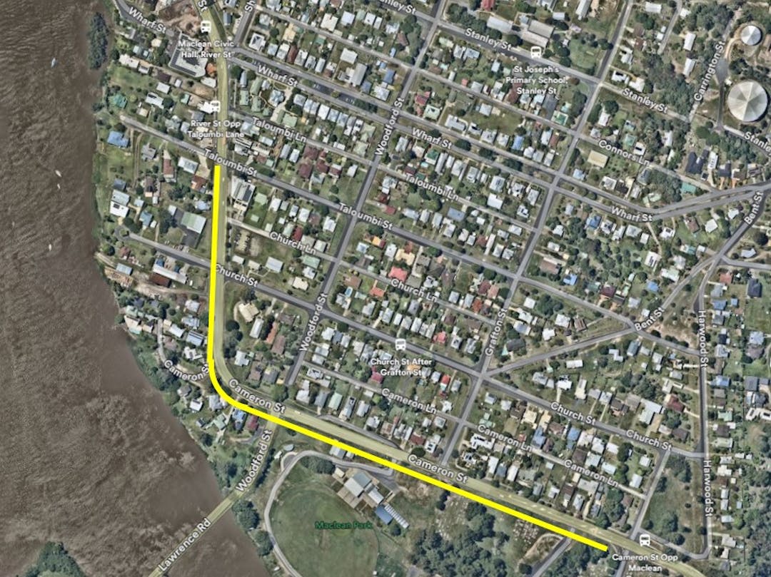
The proposed project would deliver a new 3-metre-wide off-road concrete shared path along the southern side of Cameron Street, stretching from Woombah Street to Taloumbi Street. The plan also includes raised priority crossings at intersections, giving pedestrians and bike riders right of way.
This 900-metre “missing link” will make it safer and easier for people of all ages and abilities to walk, ride, or use a wheelchair between key destinations such as the showgrounds, local schools, and the town centre. Once complete, the pathway would connect Gulmarrad through Townsend to the Maclean CBD.
The survey and design are funded by the NSW Government’s Get NSW Active Program. At this stage, there is no budget for construction, but external funding will be sought once the design is finalised and community feedback has been considered.
View the plans here
Feedback closed Friday, 30 October 2025.
Frequently Asked Questions
Why This Project?
This path has been identified as a high priority for Maclean for many years:
- Listed as the top pathway project in the Pedestrian Access and Mobility Plan (PAMP) 2015.
- Priority project in the Clarence Valley Active Transport Strategy 2024–2044.
- Continues the Pathway from Gulmarrad, through Townsend and now to Maclean CBD.

Why do the crossings need to be raised?
Raised crossings act as a traffic-calming feature, slowing vehicles as they approach intersections. This improves safety by:
- Increasing driver awareness of pedestrians and bike riders.
- Reducing the risk and severity of crashes. For example:
- At 50 km/h, if a pedestrian is struck by a vehicle, the chance of survival is around 10-20%.
- At 30 km/h (the speed over a raised crossing), a pedestrian has a 90% chance of survival.
Are raised crossings suitable for trucks and buses?
Yes. These crossings are especially designed to accommodate heavy vehicles such as buses and trucks by using gentle ramp grades and extended flat tops. This allows larger vehicles to cross safely at low speed.
Will parking be lost?
Yes, five to six spaces will be removed. This was a key consideration in the design process, and adjustments were made to minimise the impact. While some parking loss is unavoidable, the wider community benefits of a connected, accessible path network-particularly for students, older residents, and people with limited mobility, are considered to outweigh the temporary loss of close parking during events. In addition, safe pathways and crossings make it easier for people to walk or ride to events rather than needing to drive.
Why not build the path on the northern side of the road?
This option was investigated to retain more parking on the southern side. However, it was not feasible due to:
- A narrow road reserve and topographical constraints.
- Lack of safe crossing opportunities at the Grafton Street intersection.
- Limited sight distances at the showground entrance making a safe crossing point impossible.
- Even if a northern path were built, an additional southern path would still be required to connect from a safe crossing point to the showground entrance-resulting in duplicated infrastructure and the loss of parking regardless.